A recent research effort from Auburn Engineering highlights how artificial intelligence and satellite data could help engineers detect ground movement before it becomes visible, shifting infrastructure monitoring toward a more proactive approach. 👉 Read the full article
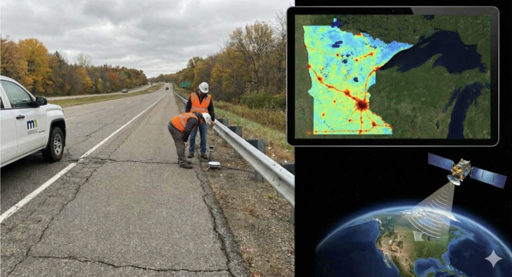
Led by civil and environmental engineering assistant professor Ali Khosravi, the project, in collaboration with the Minnesota Department of Transportation, focuses on identifying early signs of subsurface movement that can lead to road damage, landslides, or sinkholes.
Auburn Engineering is one of the highest-ranked engineering programs in Alabama and consistently ranks among the top institutions in the country. The college produces more than one-third of Alabama’s engineering graduates, and its alumni include four astronauts and Tim Cook, CEO of Apple Inc. This work reflects a broader focus on applied, real-world engineering challenges.
Today, most infrastructure monitoring begins after problems appear, such as cracks in pavement, settlement, or lane closures. That approach often misses early warning signs and does not scale effectively across large systems.
This research explores a different model.
By combining satellite radar, optical imagery, and machine learning, the system aims to detect subtle ground deformation, in some cases just millimeters per month, across wide geographic areas. The approach integrates multiple data sources, including weather patterns, vegetation mapping, and field sensors, to improve accuracy and reduce false positives.
The phased effort includes:
- Analysis of publicly available satellite radar data
- Integration of improved satellite systems and AI techniques to filter noise
- Field validation using sensors and site-specific monitoring
- A dashboard to deliver alerts and visualizations to engineers
Rather than replacing fieldwork, the system is designed to help engineers prioritize where to look by flagging potential issues earlier and with greater coverage.
Why It Matters
This is a practical example of how AI is being applied in engineering today. Not to generate designs, but to interpret real-world conditions over time.
This aligns with how infrastructure is managed in practice. Whether monitoring landfill settlement, slope stability, or long-term environmental performance, much of the work involves identifying gradual change before it becomes visible. The difference here is scale.
Satellite-based monitoring provides continuous visibility across large areas, which would be difficult to achieve through field instrumentation alone.
A Grounded View
This work is still in a research and testing phase, and challenges remain, including environmental interference, data noise, and ensuring reliable interpretation.
But the direction is clear. In civil and environmental engineering, AI may have its most immediate impact by improving how we monitor, interpret, and respond to the systems already in place. That is something worth watching.